Geospatial data
Maps are not just for orientation in space, they can show us how different phenomena are related to the place where they occur. Thanks to maps, humanities scholars can look at a whole range of socio-cultural phenomena from an entirely new perspective. The area in which the humanities and geography meet is referred to as spatial humanities.
One of the impetuses for the development of this discipline has been the progressive globalization as well as technological advances in geography and cartography. The development of geographic information systems and their emergence in the social sciences and humanities has opened up the possibility of a completely new way of looking at problems in relation to place and space. Thanks to the easy availability of applications and software for geocoding, digital mapping and other work with spatial data, a number of interesting projects are emerging, including in fields such as history, literary studies and religious studies.
But maps need not be seen only as an exploratory tool. Interactive maps can be used to tell a story or present a historical event in such a way that the reader can perceive spatial relationships in addition to the temporal dimension. Scholars in the humanities are thus creating cartographic outputs that are visually engaging, information-rich, and can be applied to the occurrence of abstract concepts.
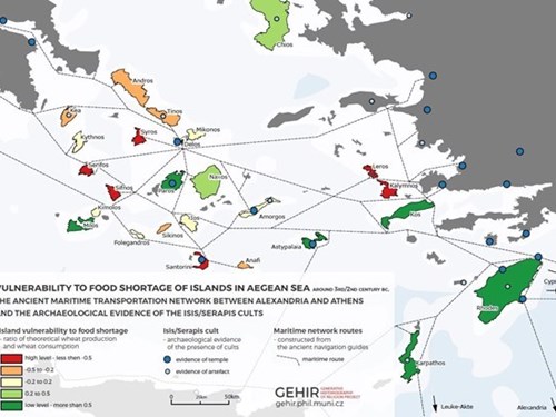
There are several very interesting projects at Masaryk University where we can use maps to investigate, for example, the spread of ancient religions, as presented by the GEHIR project. This is an interdisciplinary research by scientists from the Department of Religious Studies who, in collaboration with geographers and computer scientists, have investigated ancient Greco-Roman religions using computer modelling, geographic information systems and other methods.
Other interesting projects are GIStralik, where we can view artefacts related to folk traditions, especially in the Moravian region, on a map base, or the database Historical use of the landscape of the Bohemian-Moravian Highlands in prehistoric and medieval times.
Mapping tools
- QGis A freely available open source geographic information system.
- StoryMap StoryMapJS is a free tool that allows you to present stories and events using visualizations and maps.
- Harvard WorldMap Harvard Worldmap is an online mapping tool that allows users to create complex layered maps using large datasets.
- CartoDB CartoDB is a web-based platform that allows users to work with spatial data and maps.
- HistoryPin Historypin is a digital archive of historical photographs, videos, audio recordings and personal memories that users place on map backgrounds.
- Leaflet Leaflet is an open-source JavaScript library for interactive maps.
Interesting projects
Online courses
- Spatial Image Analytics: an introduction
- Displaying a Georeferenced Map in KnightLab’s StoryMap JS
- Using Geospatial Data to Inform Historical Research in R
- Web Mapping with Python and Leaflet
- Using JavaScript to Create Maps of Correspondence
- Geocoding Historical Data using QGIS
- Intro to Google Maps and Google Earth
- Installing QGIS 2.0 and Adding Layers

